
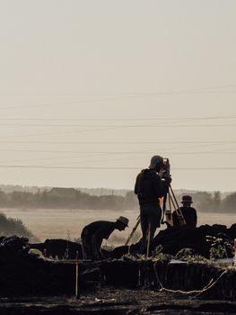
You may have seen someone beside a road looking through a tripod-mounted instrument and wondered, “What are they measuring?” That person may be a surveyor gathering precise information about the land. Their work can determine where a fence belongs, whether a new building is positioned correctly, or how a road should cross uneven terrain.
So, what do surveyors do? They measure and map land, establish property boundaries, document elevations, and identify the exact locations of natural and built features. They combine field measurements with legal records, specialized software, and mathematical calculations to produce maps and reports used in property transactions, construction, engineering, transportation, and land development.
What Are a Surveyor’s Main Responsibilities?
A surveyor’s responsibilities depend on the project, but the central goal is accuracy. A small measurement error could affect a property line, drainage plan, utility location, or construction layout. Surveyors therefore follow established procedures and carefully verify their results.
Typical responsibilities include:
- Measuring distances, directions, angles, and elevations
- Locating property corners and other boundary markers
- Researching deeds, plats, maps, easements, and public records
- Recording the positions of buildings, roads, utilities, trees, waterways, and terrain features
- Using field data to prepare maps, drawings, and legal descriptions
- Resolving differences between existing records and current site conditions
- Marking reference points that construction teams can follow
- Checking completed work for accuracy and compliance with project requirements
- Explaining findings to clients, engineers, architects, attorneys, contractors, and public officials
Licensed surveyors may also certify documents that establish property boundaries or confirm official measurements. In the United States, licensing requirements vary by jurisdiction, although surveyors generally must be licensed before offering professional surveying services directly to the public.
What Does a Surveyor Do on a Typical Project?
A project often begins in the office rather than outdoors. The surveyor reviews the client’s request and studies existing information about the site. This research may include property deeds, subdivision plans, previous surveys, title documents, construction drawings, and government records.
The field crew then visits the location. Team members search for existing monuments such as iron rods, concrete markers, stakes, or other reference points. They use surveying instruments to collect coordinates, elevations, angles, and distances. Depending on the site, they may also document physical features such as walls, fences, sidewalks, streams, utility structures, and changes in ground level.
Back in the office, the surveyor processes and compares the measurements. Specialized mapping and drafting software helps transform raw observations into usable plans. If records conflict with physical evidence, the surveyor investigates the discrepancy rather than simply choosing the most convenient answer.
The finished product may be a boundary map, topographic plan, construction layout, elevation certificate, legal description, or digital dataset. The exact document depends on why the survey was requested.
Common Types of Surveying Work
Boundary surveying
Boundary surveyors determine the location of property lines. They examine legal records, locate physical evidence on the land, take measurements, and apply relevant property law. Homeowners may need this service before installing a fence, adding a garage, dividing land, or resolving a boundary disagreement.
Construction surveying
Construction surveyors transfer information from design plans to the physical site. They mark where foundations, roads, utilities, bridges, and other structures should be built. They may return during construction to verify positions, dimensions, and elevations.
Topographic surveying
A topographic survey records both natural and human-made features, along with changes in elevation. Engineers and architects use this information when planning buildings, drainage systems, landscaping, roads, and other improvements.
Geodetic surveying
Geodetic surveyors work across large areas and account for the Earth’s shape and curvature. Their measurements help establish dependable reference systems for mapping, navigation, infrastructure, and scientific work.
Hydrographic and specialized surveying
Some surveyors measure shorelines, rivers, harbors, lakebeds, or ocean floors. Others work in mining, transportation, utilities, forensic investigations, or aerial mapping. Technologies such as drones and laser scanners can help collect detailed information, but trained professionals must still plan the work, evaluate accuracy, and interpret the results.
Where Do Surveyors Work?
Surveying combines outdoor fieldwork with office-based analysis. In the field, surveyors may work on residential lots, construction sites, highways, farms, forests, industrial properties, mines, or remote land. Conditions can include heat, cold, rain, traffic, rough terrain, insects, and long periods of walking or standing.
Office work involves reviewing records, performing calculations, processing measurements, creating maps, writing reports, and coordinating with clients or project teams. Surveyors commonly work for engineering and surveying firms, construction companies, utility providers, government agencies, and land-development businesses. Some operate their own practices.
Most positions are full time, although schedules may change with travel, weather, project deadlines, or construction needs. The U.S. Bureau of Labor Statistics overview of the surveying profession provides additional information about duties, education, licensing, and working conditions.
What Tools Do Surveyors Use?
Modern surveying is highly technical. A surveyor may use a total station to measure angles and distances, Global Navigation Satellite System equipment to determine coordinates, and digital levels to calculate elevation differences. Laser scanners can capture millions of points across a surface, while drones may collect aerial images of large or difficult-to-reach sites.
Surveyors also rely on computer-aided design, mapping, and geographic information system software. However, equipment does not replace professional judgment. Satellite signals may be obstructed, old records may be unclear, and different pieces of evidence may conflict. Surveyors must understand the limitations of their tools and recognize when a measurement needs to be checked.
Skills Surveyors Need
Successful surveyors need a combination of technical ability, practical awareness, and interpersonal skills.
- Attention to detail: Measurements, field notes, calculations, and legal descriptions must be precise.
- Mathematical ability: Geometry, trigonometry, and data analysis support many surveying calculations.
- Problem-solving: Surveyors must reconcile old records, missing markers, difficult terrain, and conflicting evidence.
- Spatial awareness: They need to visualize distances, elevations, boundaries, and proposed changes to a site.
- Technology skills: Surveying instruments and mapping software require careful setup and operation.
- Communication: Findings must be explained clearly to clients, crews, officials, and other professionals.
- Physical stamina: Fieldwork can involve carrying equipment and walking over steep or uneven ground.
- Time management: Surveyors often coordinate field crews, office tasks, travel, and project deadlines.
Experienced surveyors may supervise employees, train technicians, and manage several assignments at once. People interested in how leadership and instruction apply across careers can also explore the key responsibilities and skills of a training director.
How Surveying Affects Everyday Life
Surveyors contribute to many systems people use without noticing. Their measurements help keep buildings within legal property limits, roads aligned with design plans, utilities placed in the intended corridors, and drainage systems set at workable elevations. Survey information can also help buyers understand what land they are purchasing and help communities maintain reliable geographic records.
A survey is not the same as a casual measurement with a tape, phone, or online map. Digital parcel maps may provide useful general information, but they do not necessarily establish an exact legal boundary. When a project depends on precise property lines or certified measurements, a qualified surveyor may be necessary.
Is Surveying a Good Career Fit?
Surveying may appeal to someone who enjoys technology but does not want to remain at a desk all day. It offers a mix of fieldwork, mathematics, mapping, research, and real-world problem-solving. The profession can also suit people who value independent decision-making and producing concrete results that guide major projects.
Education and licensing pathways vary by state and position. Professional surveyors commonly complete relevant college education, gain supervised experience, and pass required examinations. Surveying technicians may enter with different educational backgrounds and learn many tasks through technical training and supervised work.
Ultimately, surveyors do much more than place stakes in the ground. They turn physical measurements, historical records, and legal principles into dependable information about location. That information helps property owners, builders, engineers, governments, and communities make decisions with greater accuracy and confidence.